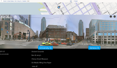
In a blog post today, our old friend Chris Pendleton officially announces a new version of Bing Maps Streetside, which now uses the Microsoft Research Street Slide technology. We told you about the apparent switch back on May 7th, but this blog post makes it official:
These changes represent a significant enhancement for desktop browsers, enabling you to quickly pan up and down the street to see the neighborhood and find businesses. We are doing this by providing street level panoramas so you can take a virtual walk through the streets with a view of locations and landmarks. As you slide the street level imagery sideways, the view of the sidewalk is seamlessly constructed including an overlay of business listings, street names and store fronts.
A quick check of the streets of Seattle reveals that there’s still some work to be done: in this view much of the block between Seneca and University has gone missing, the 1201 3rd building appears (in the background) twice, etc., but still, the Street Slide imagery is smooth and as the blog post says, easier to navigate than the “old version” Street Side:

As we said earlier, the new functionality, while promoted as “a significant enhancement for desktop browsers”, looks like it would be a natural on mobile devices, where location based services will really shine. Definitely a step in the right direction!